© 2004 Perfect Flight - Created by Marco Martini
All rights reserved
ESTIMATED TIME TO COMPLETE
20 minutes
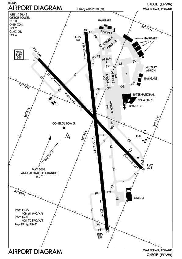
AIRPORT FACILITY
Okecie (EPWA)
EPWA - Okecie Approach Adventure
© 2004 Perfect Flight - Created by Marco Martini
All rights reserved
ESTIMATED TIME TO COMPLETE
20 minutes
AIRPORT FACILITY
Okecie (EPWA)
| ATIS | 120.450 MHz |
| Clearance Delivery | 121.600 MHz |
| Ground | 121.900 MHz |
| Tower | 118.300 MHz |
| Approach | 128.800 MHz |
| Approach | 129.375 MHz |
| Latitude | N52*09.95' |
| Longitude | E20*58.03' |
| Elevation | 361 FT |
| Runway | Length | Surface | ILS_ID | ILS_Freq | ILS_Hdg |
| 15 | 12088 | Asphalt | |||
| 33 | 12088 | Asphalt | WA | 110.300 | 328 |
| 11 | 9190 | Asphalt | WAS | 109.900 | 111 |
| 29 | 9190 | Asphalt |
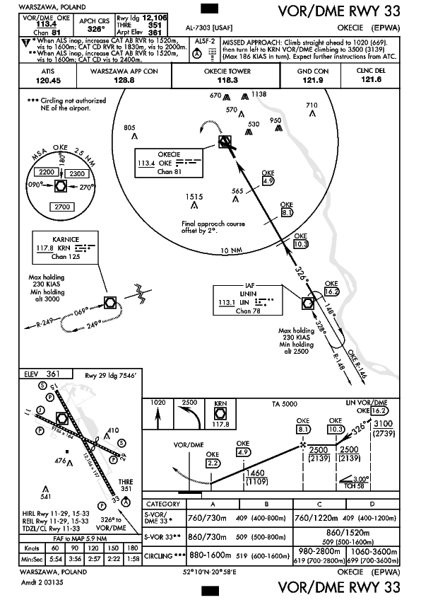
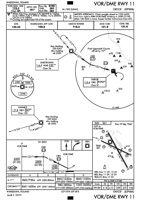
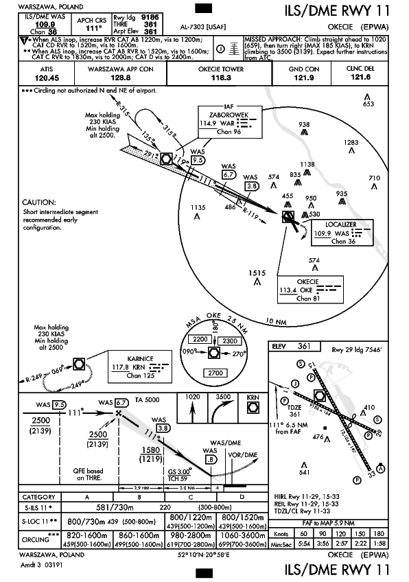
Approach plates
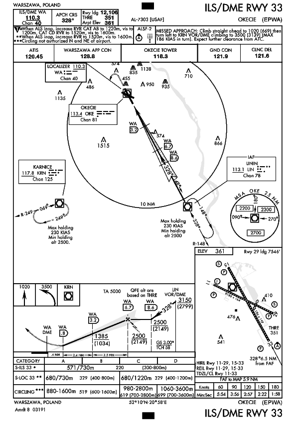
VORDME RWY 33
VOR DME RWY 11
V ILSDME RWY 11
V ILSDME RWY 33
V VORDME RWY 29
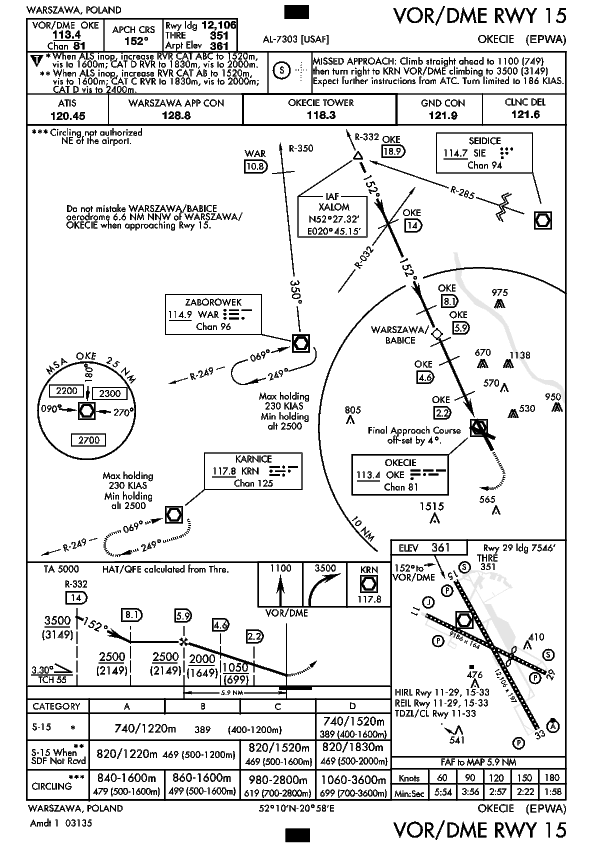
V VOR DME RWY 15
WARSAW (OKE)
Type: VOR/DME
Class: High altitude
Frequency: 113.40 MHz
Morse: - - - - . - .
WARSAW (WAG)
Type: NDB
Class: H
Frequency: 336.0 kHz
Morse: . - - . - - - .
WARSAW (AY)
Type: NDB
Class: MH
Frequency: 375.0 kHz
Morse: . - - . - -
PIASECZNO (PNO)
Type: NDB
Class: H
Frequency: 330.0 kHz
Morse: . - - . - . - - -
WARSAW (WAO)
Type: NDB
Class: HH
Frequency: 412.0 kHz
Morse: . - - . - - - -
WARSAW (W)
Type: NDB
Class: MH
Frequency: 361.0 kHz
Morse: . - -
ABOUT THE FLIGHT
Fly the Boeing 737-400 and land to EPWA - Okecie. Follow the ATC
instructions. Head to the airport, land on the assigned runway, and taxi to the
parking area of your choice.
There is no flight plan associated with this Flight, so no course line will show
up in the GPS and there won't be any information in the Navigation Log.
NOTE
For variety, you can re-fly this Flight with a different aircraft, at a
different time or in a different season or with different weather conditions.
For maximum realism, use the Real-World Weather feature.