© 2006 Perfect Flight - Created by Marco Martini
All rights reserved
ESTIMATED TIME TO COMPLETE
20 minutes
AIRPORT FACILITY - Terminal Procedures Publication
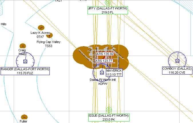
KDFW - Dallas Ft Worth Intl
Adventure
© 2006 Perfect Flight - Created by Marco Martini
All rights reserved
ESTIMATED TIME TO COMPLETE
20 minutes
AIRPORT FACILITY -
Terminal Procedures Publication
| Airport KDFW | |
| Full name | Dallas-Ft Worth Intl |
| City | Dallas-Ft Worth |
| State | Texas |
| Country | United States |
| ATIS Frequency | 123.77 MHz 135.92 MHz |
| Clearance Delivery | 128.25 MHz |
| Ground Frequency | 121.65 MHz 121.80 MHz 121.85 MHz |
| Tower Frequency | 124.15 MHz 126.55 MHz 127.50 MHz |
| Tower Frequency | 134.90 MHz |
| Departure Frequency | 118.10 MHz 118.55 MHz 120.50 MHz |
| Departure Frequency | 124.30 MHz 124.82 MHz 125.13 MHz |
| Departure Frequency | 125.20 MHz 126.47 MHz |
| Approach Frequency | 118.10 MHz 118.42 MHz 119.40 MHz |
| Approach Frequency | 119.87 MHz 125.02 MHz 125.20 MHz |
| Approach Frequency | 125.27 MHz 127.07 MHz 133.15 MHz |
| Approach Frequency | 133.52 MHz 133.62 MHz 135.50 MHz |
| Approach Frequency | 124.30 MHz 135.98 MHz |
| UNICOM Frequency | 122.95 MHz |
| Altitude | 603 ft |
| Mag. Variation | -6.5 deg |
| Lat/Lon | N32°53.76' W097°02.23' |
| Runway 13L | |
| Airport | Dallas-Ft Worth Intl |
| Approach course | 129 deg |
| Altitude/Surface | 603 ft Concrete |
| Length/Width | 9004 ft 200 ft |
| Lat/Lon | N32°54.74' W097°01.27' |
| Rwy ILS/GS/DME 31R IRRA | |
| Airport | Dallas-Ft Worth Intl |
| ILS Frequ./Range | 110.90 MHz 27 nm |
| Approach course | 309 deg |
| Glideslope altitude | 2200 ft at 5 nm distance |
| Altitude/Surface | 603 ft Concrete |
| Length/Width | 9004 ft 200 ft |
| Rwy ILS/GS/DME 13R ILWN | |
| Airport | Dallas-Ft Worth Intl |
| ILS Frequ./Range | 109.50 MHz 27 nm |
| Approach course | 133 deg |
| Glideslope altitude | 2200 ft at 5 nm distance |
| Altitude/Surface | 603 ft Concrete |
| Length/Width | 9307 ft 150 ft |
| Runway 31L | |
| Airport | Dallas-Ft Worth Intl |
| Approach course | 313 deg |
| Altitude/Surface | 603 ft Concrete |
| Length/Width | 9307 ft 150 ft |
| Rwy ILS/GS/DME 17L IPPZ | |
| Airport | Dallas-Ft Worth Intl |
| ILS Frequ./Range | 111.75 MHz 27 nm |
| Approach course | 174 deg |
| Glideslope altitude | 2200 ft at 5 nm distance |
| Altitude/Surface | 603 ft Concrete |
| Length/Width | 8517 ft 150 ft |
| Rwy ILS/GS/DME 35R IAJQ | |
| Airport | Dallas-Ft Worth Intl |
| ILS Frequ./Range | 111.75 MHz 27 nm |
| Approach course | 354 deg |
| Glideslope altitude | 2200 ft at 5 nm distance |
| Altitude/Surface | 603 ft Concrete |
| Length/Width | 8517 ft 150 ft |
| Rwy ILS/GS 17R IJHZ | |
| Airport | Dallas-Ft Worth Intl |
| ILS Frequ./Range | 111.35 MHz 27 nm |
| Approach course | 174 deg |
| Glideslope altitude | 2200 ft at 5 nm distance |
| Altitude/Surface | 603 ft Concrete |
| Length/Width | 13427 ft 200 ft |
| Rwy ILS/GS 35L IUWX | |
| Airport | Dallas-Ft Worth Intl |
| ILS Frequ./Range | 111.35 MHz 27 nm |
| Approach course | 354 deg |
| Glideslope altitude | 2200 ft at 5 nm distance |
| Altitude/Surface | 603 ft Concrete |
| Length/Width | 13427 ft 200 ft |
| Rwy ILS/GS/DME 17C IFLQ | |
| Airport | Dallas-Ft Worth Intl |
| ILS Frequ./Range | 110.30 MHz 27 nm |
| Approach course | 174 deg |
| Glideslope altitude | 2200 ft at 5 nm distance |
| Altitude/Surface | 603 ft Concrete |
| Length/Width | 11411 ft 150 ft |
| Rwy ILS/GS/DME 35C IPKQ | |
| Airport | Dallas-Ft Worth Intl |
| ILS Frequ./Range | 110.30 MHz 27 nm |
| Approach course | 354 deg |
| Glideslope altitude | 2200 ft at 5 nm distance |
| Altitude/Surface | 603 ft Concrete |
| Length/Width | 11411 ft 150 ft |
| Rwy ILS/GS/DME 18R IVYN | |
| Airport | Dallas-Ft Worth Intl |
| ILS Frequ./Range | 111.90 MHz 27 nm |
| Approach course | 174 deg |
| Glideslope altitude | 2200 ft at 5 nm distance |
| Altitude/Surface | 603 ft Concrete |
| Length/Width | 11411 ft 150 ft |
| Rwy ILS/GS/DME 36L IBXN | |
| Airport | Dallas-Ft Worth Intl |
| ILS Frequ./Range | 111.90 MHz 27 nm |
| Approach course | 354 deg |
| Glideslope altitude | 2200 ft at 5 nm distance |
| Altitude/Surface | 603 ft Concrete |
| Length/Width | 11411 ft 150 ft |
| Rwy ILS/GS 18L ICIX | |
| Airport | Dallas-Ft Worth Intl |
| ILS Frequ./Range | 110.55 MHz 27 nm |
| Approach course | 174 deg |
| Glideslope altitude | 2200 ft at 5 nm distance |
| Altitude/Surface | 603 ft Concrete |
| Length/Width | 13427 ft 200 ft |
| Rwy ILS/GS 36R IFJN | |
| Airport | Dallas-Ft Worth Intl |
| ILS Frequ./Range | 110.55 MHz 27 nm |
| Approach course | 354 deg |
| Glideslope altitude | 2200 ft at 5 nm distance |
| Altitude/Surface | 603 ft Concrete |
| Length/Width | 13427 ft 200 ft |
ABOUT THE FLIGHT
Follow the ATC
instructions. Head to the airport, land on the assigned runway, and taxi to the
parking area of your choice.
There is no flight plan associated with this Flight, so no course line will show
up in the GPS and there won't be any information in the Navigation Log.
NOTE
For variety, you can re-fly this Flight with a different aircraft, at a
different time or in a different season or with different weather conditions.
For maximum realism, use the Real-World Weather feature.