© 2006 Perfect Flight - Created by Marco Martini
All rights reserved
ESTIMATED TIME TO COMPLETE
20 minutes
AIRPORT FACILITY -
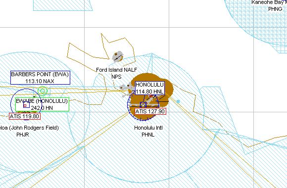
PHNL - Honolulu Intl
Adventure
© 2006 Perfect Flight - Created by Marco Martini
All rights reserved
ESTIMATED TIME TO COMPLETE
20 minutes
AIRPORT FACILITY -
| Airport PHNL | |
| Full name | Honolulu Intl |
| City | Honolulu |
| State | Hawaii |
| Country | United States |
| ATIS Frequency | 127.90 MHz |
| Clearance Delivery | 121.40 MHz |
| Ground Frequency | 121.90 MHz |
| Tower Frequency | 118.10 MHz 123.90 MHz |
| Departure Frequency | 118.30 MHz 120.90 MHz 124.80 MHz |
| Approach Frequency | 118.30 MHz 120.90 MHz 119.10 MHz |
| Approach Frequency | 124.80 MHz |
| FSS Frequency | 122.10 MHz 122.20 MHz 122.60 MHz |
| FSS Frequency | 123.60 MHz |
| Altitude | 13 ft |
| Mag. Variation | -10.9 deg |
| Lat/Lon | N21°19.12' W157°55.34' |
| Runway 8R | |
| Airport | Honolulu Intl |
| Approach course | 79 deg |
| Altitude/Surface | 13 ft Asphalt |
| Length/Width | 11994 ft 200 ft |
| Runway 26L | |
| Airport | Honolulu Intl |
| Approach course | 259 deg |
| Altitude/Surface | 13 ft Asphalt |
| Length/Width | 11994 ft 200 ft |
| Rwy ILS/GS 8L IHNL | |
| Airport | Honolulu Intl |
| ILS Frequ./Range | 111.70 MHz 27 nm |
| Approach course | 79 deg |
| Glideslope altitude | 1600 ft at 5 nm distance |
| Altitude/Surface | 13 ft Asphalt |
| Length/Width | 12294 ft 150 ft |
| Runway 26R | |
| Airport | Honolulu Intl |
| Approach course | 259 deg |
| Altitude/Surface | 13 ft Asphalt |
| Length/Width | 12294 ft 150 ft |
| Rwy ILS/GS/DME 4R IIUM | |
| Airport | Honolulu Intl |
| ILS Frequ./Range | 110.50 MHz 27 nm |
| Approach course | 42 deg |
| Glideslope altitude | 1600 ft at 5 nm distance |
| Altitude/Surface | 13 ft Asphalt |
| Length/Width | 9008 ft 150 ft |
| Runway 22L | |
| Airport | Honolulu Intl |
| Approach course | 222 deg |
| Altitude/Surface | 13 ft Asphalt |
| Length/Width | 9008 ft 150 ft |
| Runway 4L | |
| Airport | Honolulu Intl |
| Approach course | 42 deg |
| Altitude/Surface | 13 ft Asphalt |
| Length/Width | 6958 ft 150 ft |
| Runway 22R | |
| Airport | Honolulu Intl |
| Approach course | 222 deg |
| Altitude/Surface | 13 ft Asphalt |
| Length/Width | 6958 ft 150 ft |
| Runway 8W | |
| Airport | Honolulu Intl |
| Approach course | 79 deg |
| Altitude/Surface | 13 ft Water |
| Length/Width | 5000 ft 300 ft |
| Runway 8W | |
| Airport | Honolulu Intl |
| Approach course | 79 deg |
| Altitude/Surface | 13 ft Water |
| Length/Width | 5000 ft 300 ft |
| Runway 4W | |
| Airport | Honolulu Intl |
| Approach course | 42 deg |
| Altitude/Surface | 13 ft Water |
| Length/Width | 3000 ft 150 ft |
| Runway 22W | |
| Airport | Honolulu Intl |
| Approach course | 222 deg |
| Altitude/Surface | 13 ft Water |
| Length/Width | 3000 ft 150 ft |
ABOUT THE FLIGHT
Follow the ATC
instructions. Head to the airport, land on the assigned runway, and taxi to the
parking area of your choice.
There is no flight plan associated with this Flight, so no course line will show
up in the GPS and there won't be any information in the Navigation Log.
NOTE
For variety, you can re-fly this Flight with a different aircraft, at a
different time or in a different season or with different weather conditions.
For maximum realism, use the Real-World Weather feature.